There is a particular kind of light that settles over the eastern Free State in the late afternoon, writes Miriam Kimvangu.
Towns across this part of the province were constructed using locally quarried stone, creating a cohesive architectural identity that still distinguishes the area today. Travelling through these towns offers insight into settlement patterns, agricultural development and the relationship between landscape and livelihood.
Also see: Must-visit restaurants in the Eastern Cape
Ladybrand
Ladybrand was established in 1867 and named after Lady Cathcart. Its position near the Lesotho border has long made it an important administrative and trade centre. The town contains a notable concentration of late nineteenth-century sandstone buildings, including churches, civic structures and private homes that reflect both British colonial influence and local adaptation to climate conditions. In recent years, Ladybrand has developed a modest arts and cultural profile. Historic buildings have been repurposed into galleries and studios, contributing to a small but growing creative economy. Its proximity to Maseru also positions it as a point of cultural exchange, with cross-border movement influencing both commerce and daily life.
Ficksburg
Ficksburg, founded in the same year as Ladybrand, is closely tied to agriculture. The town lies in a fertile valley along the Caledon River, where conditions are well suited to fruit farming. It is best known for its cherry orchards, which have become central to the local economy and identity. The annual cherry festival, typically held in November, is one of the longest-running crop festivals in South Africa. It highlights the importance of seasonal agriculture while supporting local tourism. Beyond the orchards, Ficksburg maintains a strong architectural continuity with other towns in the region, with sandstone churches and public buildings forming a consistent visual thread.
Fouriesburg
Fouriesburg was formally established in 1892, although settlement in the area predates this. The town played a notable role during the South African War, briefly serving as the capital of the Orange Free State after Bloemfontein fell to British forces. Many of Fouriesburg’s original sandstone structures remain intact, contributing to its historical character. Unlike more tourism-driven towns, Fouriesburg retains a predominantly agricultural economy, with surrounding farms producing crops and livestock. The area is also increasingly recognised for outdoor activities, including hiking, cycling and horseback trails that follow historic routes through the landscape.
Also see: In the mood to embrace nature? Here is a list of Cape Town’s free picnic spots
Clarens
Clarens has developed into the primary tourism hub of the eastern Free State. Established in 1912, the town is situated at the foothills of the Maloti Mountains, which significantly influence its climate and scenery. Clarens is widely known for its concentration of art galleries and craft shops, many of which are located around the central town square. This creative sector has become a key driver of the local economy. In addition to its cultural appeal, Clarens serves as a base for outdoor recreation. Activities include hiking, fly fishing, mountain biking and guided nature experiences in the surrounding highlands.
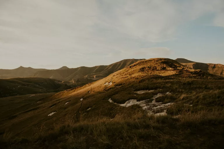
Golden Gate Highlands National Park
Located adjacent to Clarens, Golden Gate Highlands National Park was proclaimed in 1963 to protect a representative portion of the region’s high-altitude grassland ecosystem. The park is characterised by its prominent sandstone formations, which display distinct layering caused by ancient sedimentation processes.
The park’s name refers to the golden colour of the cliffs at sunrise and sunset, a result of iron oxide within the sandstone. These formations are not only visually striking but also scientifically significant, providing insight into the geological history of southern Africa. Golden Gate supports a range of wildlife species adapted to open grassland environments, including antelope such as eland and black wildebeest, as well as bird species like the bearded vulture. The park’s trail network allows visitors to engage directly with this environment, with routes varying in length and difficulty.
The role of sandstone in regional identity
The consistent use of sandstone across these towns is not incidental. Early settlers relied on locally available materials, and sandstone proved both practical and durable. Its thermal properties helped regulate indoor temperatures, while its abundance reduced construction costs. Over time, this reliance on sandstone produced a unified architectural style across the eastern Free State.
A connected regional route
Taken together, Ladybrand, Ficksburg, Fouriesburg, Clarens and Golden Gate Highlands National Park form a coherent travel route that can be explored over several days. The R26 links many of these destinations, offering a scenic drive that passes through agricultural land, river valleys and mountainous terrain.
First published by Getaway
Compiled by Miriam Kimvangu
Also see: Explore the beauty of these Free State small towns
Be the first to know – Join our WhatsApp channel for content worth tapping into. Click here to join!